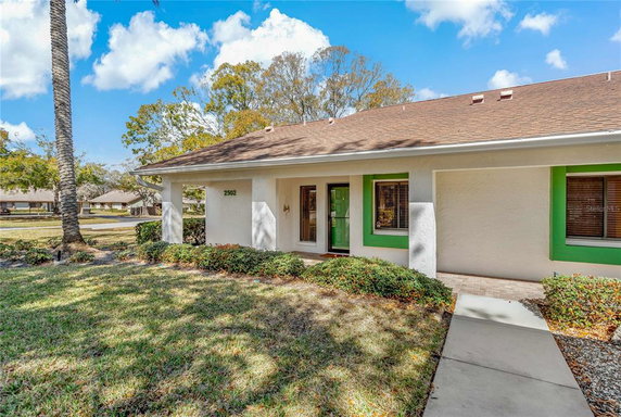
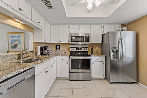
High availability buildings list units frequently.
Unit Availability helps to understand how often units in a particular building are listed for sale as compared with the neighborhood average. Units are rarely listed in buildings with low availability.
Unit Demand
Low
Units in high-demand buildings sell quicker.
Unit Demand is a measure of quickly units in a particular building sell as compared with other buildings in the neighborhood. Units in high-demand buildings sell more quickly.
Compare with Buildings in the Neighbourhood (Last 12 Months)
Compare building's average price/sq. ft. and HOA fees/sq. ft. to buildings nearby
Building Name
Avg price per square foot
AVG HOA FEE per square foot (Monthly)
2502 Royal Pines Cir
$221/sqft.
$2 /sqft.
2549 Royal Pines Cir
$180/sqft.
$3 /sqft.
2476 Enterprise Rd
$239/sqft.
$2 /sqft.
2452 Enterprise Rd
$211/sqft.
$1 /sqft.
2385 Tahitian Ln
$132/sqft.
$3 /sqft.
2286 Mexican Way
$133/sqft.
$4 /sqft.
Nearby Schools
Guardian Angels Catholic School
--
Private|Grades PK–8
2270 Evans Rd|0.85 miles away
Athenian Academy
C-
Public|Grades KG–8
2289 N Hercules Av...|0.85 miles away
Genesis Christian Academy
--
Private|Grades KG–12
2110 N Hercules Av...|1.28 miles away
Leila G. Davis Elementary
B+
Public|Grades PK–5
2630 Landmark Dr|1.58 miles away
Garrison - Jones Elementary
A
Public|Grades PK–5
3133 Garrison Rd|1.81 miles away
Academie Da Vinci Charter School
B-
Public|Grades KG–8
1060 Keene Rd|1.9 miles away
Schools
What to know about schools
Description
Guardian Angels Catholic School
--
Private|Grades PK–8
2270 Evans Rd|Less than 1 Mile Away
Athenian Academy
C-
Public|Grades KG–8
2289 N Hercules Av...|Less than 1 Mile Away
Genesis Christian Academy
--
Private|Grades KG–12
2110 N Hercules Av...|1.28 Miles Away
Leila G. Davis Elementary
B+
Public|Grades PK–5
2630 Landmark Dr|1.58 Miles Away
Garrison - Jones Elementary
A
Public|Grades PK–5
3133 Garrison Rd|1.81 Miles Away
Academie Da Vinci Charter School
B-
Public|Grades KG–8
1060 Keene Rd|1.90 Miles Away
The Depaul School for Dyslexia
--
Private|Grades 1–8
2747 Sunset Point ...|1.92 Miles Away
Enterprise Charter High School
--
Public|Grades 9–12
2461 N McMullen Bo...|1.95 Miles Away
Dunedin High School
C
Public|Grades 9–12
1651 Pinehurst Rd|1.96 Miles Away
Transit
BELCHER RD + LAURELWOOD DR
0.23 miles away|5 min walk
BELCHER RD N + MANOR BLVD N
1.73 miles away|34 min walk
BELCHER RD N + MONTCLAIR RD
1.3 miles away|25 min walk
BELCHER RD N + SUNNYDALE BLVD N
1.83 miles away|35 min walk
BELCHER RD N + WILLOW TREE TRL
0.5 miles away|10 min walk
BELCHER RD N + WORLD PKWY BLVD W
0.87 miles away|17 min walk
Transit
What to know about transit
Description
BELCHER RD + LAURELWOOD DR
0.23 miles away|5 min walk
BELCHER RD N + MANOR BLVD N
1.73 miles away|34 min walk
BELCHER RD N + MONTCLAIR RD
1.3 miles away|25 min walk
BELCHER RD N + SUNNYDALE BLVD N
1.83 miles away|35 min walk
BELCHER RD N + WILLOW TREE TRL
0.5 miles away|10 min walk
BELCHER RD N + WORLD PKWY BLVD W
0.87 miles away|17 min walk
COUNTRYSIDE BLVD + 2533
0.32 miles away|7 min walk
COUNTRYSIDE BLVD & # 2684
0.91 miles away|18 min walk
COUNTRYSIDE BLVD + 2686
0.91 miles away|18 min walk
COUNTRYSIDE BLVD + 2720
1.02 miles away|20 min walk
COUNTRYSIDE BLVD + BRYN MAWR
1.31 miles away|26 min walk
COUNTRYSIDE BLVD + ENTERPRISE RD
0.25 miles away|5 min walk
COUNTRYSIDE BLVD + OAK NECK RD
0.2 miles away|4 min walk
COUNTRYSIDE BLVD + SABAL SPRINGS DR
1.27 miles away|25 min walk
COUNTRYSIDE BLVD + US HWY 19 N
0.64 miles away|13 min walk
COUNTRYSIDE RD + ENTERPRISE RD
0.26 miles away|6 min walk
COUNTY RD 1 AND MAIN
1.37 miles away|27 min walk
COUNTY RD 1 + BRAEMOOR LN
1.88 miles away|37 min walk
COUNTY RD 1 & BURNHAM LN
1.8 miles away|35 min walk
COUNTY RD 1 + ROXBURG LN
1.75 miles away|34 min walk
COUNTY RD 1 + SOLON AVE
1.7 miles away|33 min walk
COUNTY ROAD 1 + PALM LAKE LA
1.62 miles away|32 min walk
ENTERPRISE RD E + 2700
1.11 miles away|22 min walk
ENTERPRISE RD E + 2718
1.02 miles away|20 min walk
ENTERPRISE RD E + 2730
1.2 miles away|24 min walk
ENTERPRISE RD E + 2741
1.2 miles away|23 min walk
ENTERPRISE RD E + FRISCO DR
1.38 miles away|27 min walk
ENTERPRISE RD E + LANDMARK DR
1.8 miles away|35 min walk
ENTERPRISE RD E + PARKSTREAM AVE
1.62 miles away|32 min walk
ENTERPRISE RD E + VILLAGE DR
0.89 miles away|18 min walk
GREENBRIAR BLVD + FOREST DR
0.52 miles away|10 min walk
GREENBRIAR BLVD + INDIGO DR
0.8 miles away|16 min walk
GREENBRIAR BLVD + RUTLAND LN
0.3 miles away|6 min walk
GREENBRIAR BLVD + SUTTON PL
0.7 miles away|14 min walk
HERCULES AVE N + ALLARD DR
1.07 miles away|21 min walk
HERCULES AVE N + BARRINGTON DR N
1.62 miles away|32 min walk
HERCULES AVE N + CALUMET ST
1.97 miles away|38 min walk
HERCULES AVE N + CHARTER OAKS DR
1.36 miles away|27 min walk
HERCULES AVE N + LAKE CITRUS DR
1.28 miles away|25 min walk
HERCULES AVE N + LAKEWOOD DR
0.94 miles away|18 min walk
HERCULES AVE N + MONTCLAIR RD
1.47 miles away|29 min walk
HERCULES AVE N + PALM DR
1.06 miles away|21 min walk
HERCULES AVE N + SUNNYDALE BLVD
1.85 miles away|36 min walk
HERCULES AVE N + SUNSET GROVE LN
1.81 miles away|35 min walk
HERCULES AVE N + SUNSET POINT RD
1.65 miles away|32 min walk
HERCULES AVE N + UNION ST
1.3 miles away|25 min walk
KEENE RD & AMBERLEA
1.57 miles away|31 min walk
KEENE RD + AMBERLEA DR
1.56 miles away|30 min walk
KEENE RD (CR1) + MAIN ST (SR580)
1.35 miles away|26 min walk
KEENE RD + PARADISE LN
1.65 miles away|32 min walk
The Neighbourhood: Woodgate
Woodgate is a neighborhood in Pinellas County, Florida. The area has public parks and green trails for walking, jogging, and outdoor play with benches. This district hosts small shops, cafes, and grocery stores and services for daily needs. The area offers schools, medical clinics, banks, and other local services within short drives for simple errands. People use nearby bus lines, major roads, and parkways for work commutes, weekend trips, or shopping. A town hall and seasonal events give local chances to meet and take part in groups.
Neighbourhood Description
Woodgate is a neighborhood in Pinellas County, Florida. The area has public parks and green trails for walking, jogging, and outdoor play with benches. This district hosts small shops, cafes, and grocery stores and services for daily needs. The area offers schools, medical clinics, banks, and other local services within short drives for simple errands. People use nearby bus lines, major roads, and parkways for work commutes, weekend trips, or shopping. A town hall and seasonal events give local chances to meet and take part in groups.
This neighborhood indicates a good mix of people which makes it a good place for families. About 10.88% are children aged 0–14, 11.28% are young adults between 15–29, 15.32% are adults aged 30–44, 16.14% are in the 45–59 range and 46.39% are seniors aged 60 and above.
Commuting options are also varying where 84.34% of residents relying on driving, while others prefer public transit around 0.67%, walking around 0.25%, biking around 0.81%, allowing residents to choose travel modes that best fit their daily routines.
Most homes in the area are with 73.43% of units owner occupied and 26.57% are rented.
The neighborhood offers different household types. About 17.2% are single family homes and 1.64% are multi family units. Around 43.25% are single-person households, while 56.75% are multi person households. This mix works well for families, roommates, and individuals.
Education levels in the neighborhood vary widely where 18.78% of residents have bachelor’s degrees. Around 29.79% have high school or college education. Another 8.45% hold diplomas while 12.09% have completed postgraduate studies. The remaining are 30.88% with other types of qualifications.
Demographics Description
This neighborhood indicates a good mix of people which makes it a good place for families. About 10.88% are children aged 0–14, 11.28% are young adults between 15–29, 15.32% are adults aged 30–44, 16.14% are in the 45–59 range and 46.39% are seniors aged 60 and above.
Commuting options are also varying where 84.34% of residents relying on driving, while others prefer public transit around 0.67%, walking around 0.25%, biking around 0.81%, allowing residents to choose travel modes that best fit their daily routines.
Most homes in the area are with 73.43% of units owner occupied and 26.57% are rented.
The neighborhood offers different household types. About 17.2% are single family homes and 1.64% are multi family units. Around 43.25% are single-person households, while 56.75% are multi person households. This mix works well for families, roommates, and individuals.
Education levels in the neighborhood vary widely where 18.78% of residents have bachelor’s degrees. Around 29.79% have high school or college education. Another 8.45% hold diplomas while 12.09% have completed postgraduate studies. The remaining are 30.88% with other types of qualifications.
Age Demographics
10.88%(0 - 14 years old)
11.28%(15 - 29 years old)
15.32%(30 - 44 years old)
16.14%(45 - 59 years old)
46.39%(60+ years old)
Commute
0.67%
Transit
0.25%
Walk
84.34%
Drive
0.81%
Bike
Housing Ownership
73.43%
Owner Occupied
26.57%
Rental Units
Household Types
17.2%
Single Family
1.64%
Multi Family
43.25%
Single Person
56.75%
Multi Person
Education
Bachelors Degree18.78%
High School College29.79%
Diploma8.45%
Post Graduate12.09%
Others30.88%
Education
Diploma8.45%
Post Graduate12.09%
Others30.88%
Get the HelloCondo Newsletter
Real-estate tips, insights, and market reports in your inbox.
HelloCondo Is The #1 Condo Search Platform And Real Estate Recommendation Engine. Search, Find And Buy The Perfect Condo And Get Matched With The Best Agents. Finding A Condo Has Never Been So Easy.