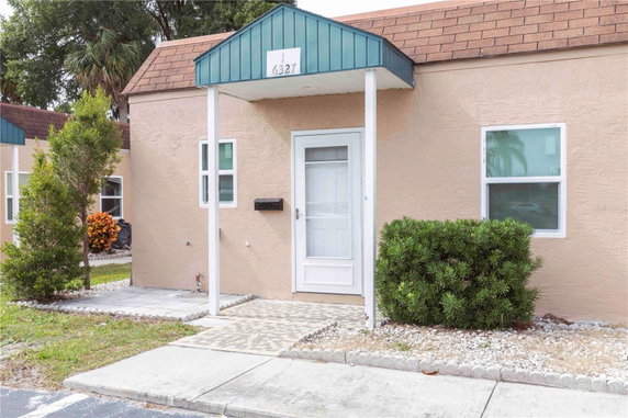
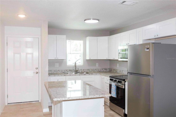
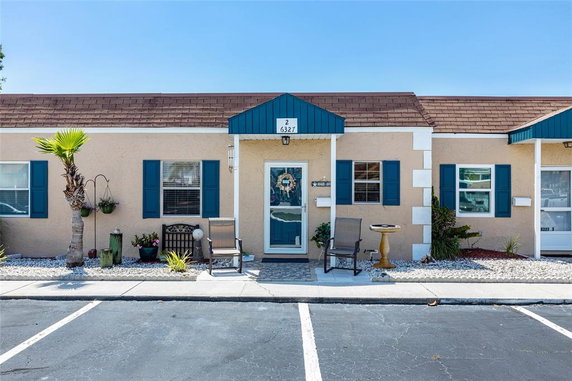
High availability buildings list units frequently.
Unit Availability helps to understand how often units in a particular building are listed for sale as compared with the neighborhood average. Units are rarely listed in buildings with low availability.
Unit Demand
High
Units in high-demand buildings sell quicker.
Unit Demand is a measure of quickly units in a particular building sell as compared with other buildings in the neighborhood. Units in high-demand buildings sell more quickly.
Compare with Buildings in the Neighbourhood (Last 12 Months)
Compare building's average price/sq. ft. and HOA fees/sq. ft. to buildings nearby
Building Name
Avg price per square foot
AVG HOA FEE per square foot (Monthly)
6327 Providence Cir
-
-
5041 Royal Palms Way
$226/sqft.
$3 /sqft.
5722 Biscayne Ct
$282/sqft.
$41 /sqft.
4516 Seagull Dr
$269/sqft.
$2 /sqft.
4939 Floramar Ter
$231/sqft.
$23 /sqft.
8210 Aquila St
$218/sqft.
$1 /sqft.
Nearby Schools
Esther School Inc- Palmetto
--
Private|Grades KG–12
5320 Palmetto Rd|0.59 miles away
Richey Elementary School
F
Public|Grades KG–5
6850 Adams St|0.93 miles away
Schwettman Education Center
--
Public|Grades 6–12
5520 Grand Blvd|1.02 miles away
Gulf High School
D
Public|Grades 9–12
5355 School Rd|1.36 miles away
Gulf Middle School
D-
Public|Grades 6–8
6419 Louisiana Ave|1.42 miles away
James M. Marlowe Elementary School
C+
Public|Grades PK–5
5642 Cecelia Dr|1.49 miles away
Schools
What to know about schools
Description
Esther School Inc- Palmetto
--
Private|Grades KG–12
5320 Palmetto Rd|Less than 1 Mile Away
Richey Elementary School
F
Public|Grades KG–5
6850 Adams St|Less than 1 Mile Away
Schwettman Education Center
--
Public|Grades 6–12
5520 Grand Blvd|1.02 Miles Away
Gulf High School
D
Public|Grades 9–12
5355 School Rd|1.36 Miles Away
Gulf Middle School
D-
Public|Grades 6–8
6419 Louisiana Ave|1.42 Miles Away
James M. Marlowe Elementary School
C+
Public|Grades PK–5
5642 Cecelia Dr|1.49 Miles Away
Mittye P. Locke Elementary School
D-
Public|Grades KG–5
4339 Evans Ave|1.98 Miles Away
Transit
Grand Blvd & Delaware Ave
0.69 miles away|14 min walk
Grand Blvd & Gulf Dr
1.01 miles away|20 min walk
Grand Blvd & Louisiana Ave
0.84 miles away|17 min walk
Grand Blvd & Missouri Ave
0.67 miles away|13 min walk
Grand Blvd & Sunshine Park Dr
1.95 miles away|38 min walk
Grand Blvd & Trouble Creek Rd (South)
1.9 miles away|37 min walk
Transit
What to know about transit
Description
Grand Blvd & Delaware Ave
0.69 miles away|14 min walk
Grand Blvd & Gulf Dr
1.01 miles away|20 min walk
Grand Blvd & Louisiana Ave
0.84 miles away|17 min walk
Grand Blvd & Missouri Ave
0.67 miles away|13 min walk
Grand Blvd & Sunshine Park Dr
1.95 miles away|38 min walk
Grand Blvd & Trouble Creek Rd (South)
1.9 miles away|37 min walk
Gulf Blvd & US Highway 19
0.81 miles away|16 min walk
Gulf Dr & Charles St
0.84 miles away|17 min walk
Gulf Dr. EB & Grand Blvd.
1.07 miles away|21 min walk
Gulf Dr & La Salle Ct
0.91 miles away|18 min walk
Gulf Dr. WB & Grand Blvd.
1.08 miles away|21 min walk
Madison St & 11th Ave
1.89 miles away|37 min walk
Madison St & 13th Ave
1.94 miles away|38 min walk
Madison St & 1st Ave
1.62 miles away|32 min walk
Madison St & 4th Ave
1.73 miles away|34 min walk
Madison St & Arthur Ave.
1.25 miles away|25 min walk
Madison St & Cecelia Dr
1.57 miles away|30 min walk
Madison St & Central Ave (Northbound)
0.93 miles away|18 min walk
Madison St & Central Ave (Southbound)
0.92 miles away|18 min walk
Madison St & Dahlia Ave
1.73 miles away|34 min walk
Madison St & Georgia Ave
1.05 miles away|21 min walk
Madison St & Gulf Dr
1.19 miles away|23 min walk
Madison St & Illinois Ave
0.96 miles away|19 min walk
Madison St & Indiana Ave
0.96 miles away|19 min walk
Madison St & Kentucky Ave
1.03 miles away|20 min walk
Madison St & Louisiana Ave
1.05 miles away|21 min walk
Madison St & Nebraska Ave
0.92 miles away|18 min walk
Madison St & School Rd
1.4 miles away|27 min walk
Madison St & Trouble Creek Rd
1.98 miles away|38 min walk
Madison St & Virginia Ave
0.95 miles away|19 min walk
Main St & Bank St
0.57 miles away|11 min walk
Main St & US 19 (East)
0.21 miles away|5 min walk
Massachusetts Ave & Bellaire Ter
1.66 miles away|32 min walk
Massachusetts Ave & Congress St
1.51 miles away|29 min walk
Massachusetts Ave & Congress St (East)
1.6 miles away|31 min walk
Massachusetts Ave & Davis St
1.42 miles away|28 min walk
Massachusetts Ave & Forest Ave
1.21 miles away|24 min walk
Massachusetts Ave & Hills Dr
1.87 miles away|36 min walk
Massachusetts Ave & Lenape Cir.
1.4 miles away|27 min walk
Massachusetts Ave & Mamoset St
1.14 miles away|22 min walk
Massachusetts Ave & Marmoset St
1.14 miles away|22 min walk
Massachusetts Ave & Millennial Way
1.75 miles away|34 min walk
Massachusetts Ave & Parison Dr
1.85 miles away|36 min walk
Massachusetts Ave & Rowan Rd
1.99 miles away|39 min walk
Massachusetts Ave & Van Buren St
1.28 miles away|25 min walk
Rowan Rd & Cypress Knoll Ave
1.95 miles away|38 min walk
Rowan Rd & Indiana Ave
1.94 miles away|38 min walk
Rowan Rd & Indiana Ave (North)
1.93 miles away|38 min walk
Rowan Rd & Indiana Ave (South)
1.92 miles away|37 min walk
Rowan Rd & Main St
1.92 miles away|37 min walk
The Neighbourhood: Northwest New Port Richey
Northwest New Port Richey is a suburban community in Pasco County, Florida. The area has parks, a riverside trail, and open green space for walking and picnics. Local retail shops, cafés, and small restaurants sit along main roads and side streets. The district includes grocery stores, basic health clinics, public schools, and other services. Drivers use nearby highways to reach Tampa, and local bus services run on main roads. This district has daily services like grocery, banks, and a small medical clinic. Cyclists and walkers find safe paths, and transportation links make travel simple and direct.
Neighbourhood Description
Northwest New Port Richey is a suburban community in Pasco County, Florida. The area has parks, a riverside trail, and open green space for walking and picnics. Local retail shops, cafés, and small restaurants sit along main roads and side streets. The district includes grocery stores, basic health clinics, public schools, and other services. Drivers use nearby highways to reach Tampa, and local bus services run on main roads. This district has daily services like grocery, banks, and a small medical clinic. Cyclists and walkers find safe paths, and transportation links make travel simple and direct.
This neighborhood indicates a good mix of people which makes it a good place for families. About 10.5% are children aged 0–14, 15.21% are young adults between 15–29, 17.47% are adults aged 30–44, 19.22% are in the 45–59 range and 37.6% are seniors aged 60 and above.
Commuting options are also varying where 85.58% of residents relying on driving, while others prefer public transit around 1.55%, walking around 2.9%, biking around 0.49%, allowing residents to choose travel modes that best fit their daily routines.
Most homes in the area are with 53.55% of units owner occupied and 46.45% are rented.
The neighborhood offers different household types. About 23.86% are single family homes and 3.1% are multi family units. Around 35.87% are single-person households, while 64.13% are multi person households. This mix works well for families, roommates, and individuals.
Education levels in the neighborhood vary widely where 11.31% of residents have bachelor’s degrees. Around 37.81% have high school or college education. Another 11.59% hold diplomas while 6.23% have completed postgraduate studies. The remaining are 33.06% with other types of qualifications.
Demographics Description
This neighborhood indicates a good mix of people which makes it a good place for families. About 10.5% are children aged 0–14, 15.21% are young adults between 15–29, 17.47% are adults aged 30–44, 19.22% are in the 45–59 range and 37.6% are seniors aged 60 and above.
Commuting options are also varying where 85.58% of residents relying on driving, while others prefer public transit around 1.55%, walking around 2.9%, biking around 0.49%, allowing residents to choose travel modes that best fit their daily routines.
Most homes in the area are with 53.55% of units owner occupied and 46.45% are rented.
The neighborhood offers different household types. About 23.86% are single family homes and 3.1% are multi family units. Around 35.87% are single-person households, while 64.13% are multi person households. This mix works well for families, roommates, and individuals.
Education levels in the neighborhood vary widely where 11.31% of residents have bachelor’s degrees. Around 37.81% have high school or college education. Another 11.59% hold diplomas while 6.23% have completed postgraduate studies. The remaining are 33.06% with other types of qualifications.
Age Demographics
10.5%(0 - 14 years old)
15.21%(15 - 29 years old)
17.47%(30 - 44 years old)
19.22%(45 - 59 years old)
37.6%(60+ years old)
Commute
1.55%
Transit
2.9%
Walk
85.58%
Drive
0.49%
Bike
Housing Ownership
53.55%
Owner Occupied
46.45%
Rental Units
Household Types
23.86%
Single Family
3.1%
Multi Family
35.87%
Single Person
64.13%
Multi Person
Education
Bachelors Degree11.31%
High School College37.81%
Diploma11.59%
Post Graduate6.23%
Others33.06%
Education
Diploma11.59%
Post Graduate6.23%
Others33.06%
Get the HelloCondo Newsletter
Real-estate tips, insights, and market reports in your inbox.
HelloCondo Is The #1 Condo Search Platform And Real Estate Recommendation Engine. Search, Find And Buy The Perfect Condo And Get Matched With The Best Agents. Finding A Condo Has Never Been So Easy.